Siang Upper Multipurpose Project: Sustainability and Indigenous Rights
- November 12, 2025 |
- Issue Brief
Summary
The Siang Upper Multipurpose Project risks ecological disruption and cultural displacement in a fragile, seismic and biodiversity-rich zone. Climate and seismic risk assessments, along with local community involvement, are needed to avoid conflict and ensure sustainable development.
The Siang Upper Multipurpose Project (SUMP), proposed in Arunachal Pradesh and envisioned as one of India’s largest hydropower reservoirs, has become a significant case study in reconciling development needs with ecological and social responsibilities. The project is planned near the Geku Village in the Upper Siang district. It was initially conceived in 2017 when NITI Aayog proposed a 10,000 MW multipurpose storage-type dam on the Siang River (also known as the Indian stretch of the Yarlung Tsangpo) in Arunachal Pradesh.[1]
This project aims to not only harness hydropower but also to control flooding and erosion downstream in the upper Brahmaputra basin, provide approximately 12 per cent free power to the state, create local job opportunities and promote infrastructure development, and lower overall costs by merging what were previously two distinct projects into one comprehensive storage solution.
However, the area where SUMP is planned is also a globally recognised biodiversity hotspot—with dense forest cover, endemic species, indigenous communities and high seismic sensitivity. Local opposition has been significant, with villagers staging repeated protests against the project over concerns of large-scale displacement, loss of ancestral lands and ecological destruction.
Strategic and Developmental Context
The northeastern region accounts for nearly 40 per cent of India’s hydropower potential, making projects like SUMP essential for regional infrastructure development. SUMP also has a strategic dimension of water security. The project emerged as a strategic response to China’s upstream hydropower activities on the Yarlung Tsangpo, particularly its large-scale dam development at Medog, near the Indian border.[2] Such developments have raised concerns in India about potential flow manipulation, flash-flood risks and long-term water security in the Brahmaputra basin.[3]
Figure 1. Approximate Location of the Dams
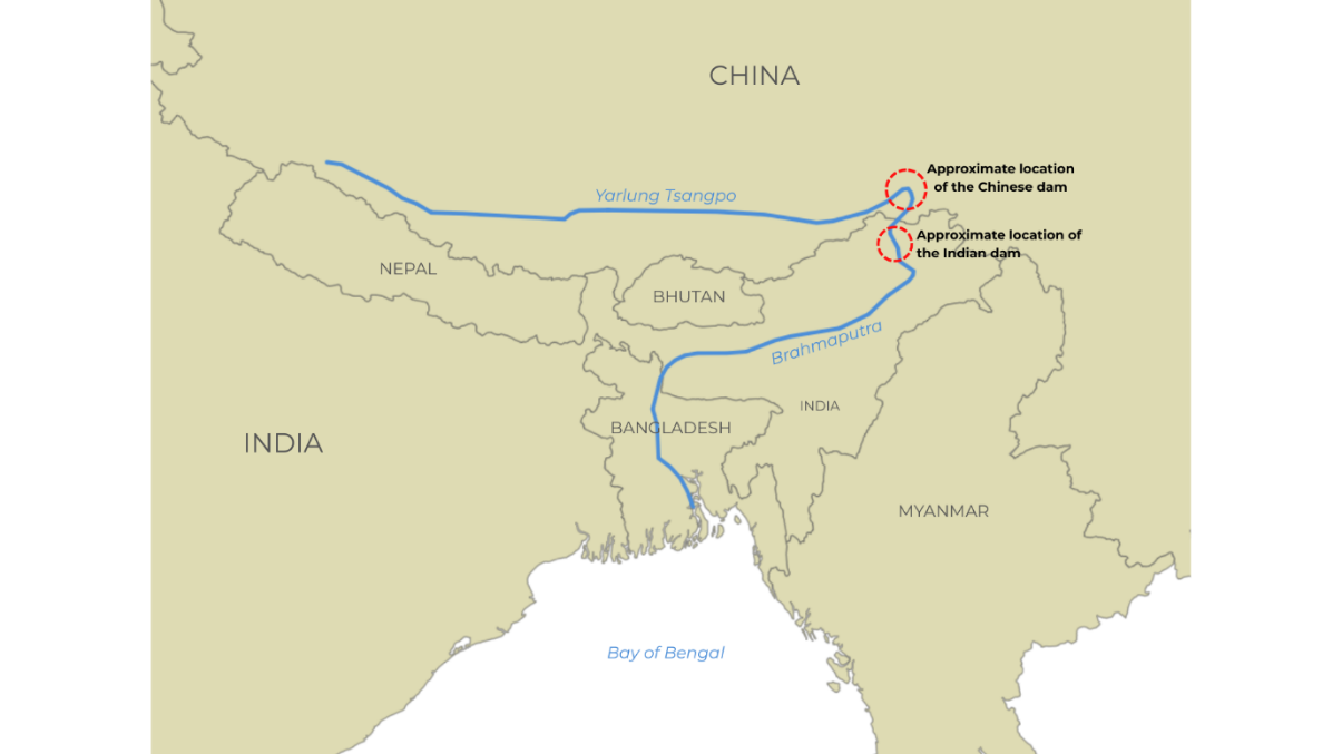
Source: Illustration made by the author using Geographical Information System (GIS).
By proposing a massive storage dam on the Siang, the main channel of the Brahmaputra in India, the Indian government has likely aimed to establish prior-use rights, enhance downstream flood control and assert hydrological sovereignty.[4] Therefore, the SUMP is not just an energy initiative but also a strategic hydro-diplomacy effort to counter Chinese influence upstream and safeguard India’s water interests.
The project further promises extensive renewable energy production, consistent regulated water flows throughout the year, stabilising peak electricity shortages in India’s northeastern and eastern grids, and accelerating socio-economic development in Arunachal Pradesh. Although these developmental efforts support national interests, they do not lessen the constitutional responsibilities regarding ecological protection and tribal rights. Such overlapping national security goals, infrastructure priorities and environmental concerns highlight the importance of the project within the context of India’s northeast.
Ecological Sensitivity and Potential Climate Risks
Despite its potential, the SUMP is located in an area of exceptional ecological sensitivity. The Siang basin spans over 15,000 square kilometres, with more than 82 per cent covered by forests, which are inhabited by numerous rare, endangered and threatened (RET) species. The area forms part of the broader Dihang–Dibang and Siang landscape, which is a known global biodiversity hotspot.[5]
Large storage dams in such environments pose several risks, including sediment build-up, flooding of habitats, forest fragmentation, disruption of riverine systems, attraction of invasive species and changes in flow patterns.[6] Furthermore, dams can obstruct fish migration, leading to isolated populations and reduced genetic diversity.[7] Moreover, the role of natural floods, which are crucial to floodplain ecosystems, may be diminished, affecting wetlands and riparian forests.[8] Alteration of natural sediment transport processes can also degrade downstream habitats and affect agricultural productivity.
Moreover, the entire eastern Himalayan region falls within seismic zone V.[9] Studies have shown that filling large reservoirs can induce seismic events due to increased load and water infiltration into fault lines.[10] Any failure of the structure could lead to catastrophic downstream outcomes, as well as the occurrence of reservoir-triggered seismicity (earthquake).[11] Moreover, constructing large dams in seismically active regions poses additional challenges to the project’s long-term stability and safety.[12] The region’s complex geology and active tectonic setting further exacerbate these risks.[13] In April 2025, scientists urged a halt to all SUMP construction, survey and clearance activities, citing risks associated with seismic zone V.[14]
India’s rationale for SUMP partly arises from concern about upstream Chinese infrastructure on the Yarlung Tsangpo.[15] Although this strategic perspective is justifiable, it also implies that the Siang region is susceptible to climate change, glacial retreat and increased risks of Glacial Lake Outburst Floods (GLOF)—a sudden and catastrophic flood caused by the failure of a natural dam (ice or moraine) holding back a glacial lake, which leads to severe destruction. Reports emphasise the risks of GLOF and climate vulnerability in the upper catchment area.[16] While a larger reservoir could mitigate some flow variations, it might also be vulnerable to abrupt surges and sediment influxes due to destabilisation events in the Himalayas. In 2021, a glacier burst in Uttarakhand damaged the Tapovan-Vishnugad hydropower project, underscoring that existing hydropower designs in the Himalayas are unlikely to be climate-resilient.[17]
Protection of the Indigenous Communities
The Siang Valley is inhabited primarily by the Adi and Galo tribes, who have long-standing customary rights over the land and forests. Before undertaking any developmental projects, the state must consult indigenous tribes. One is securing Free, Prior and Informed Consent (FPIC) from Gram Sabhas. The principle of FPIC is considered one of the basic principles for safeguarding the indigenous population’s land, resources and cultural identity. Such a principle is even recognised in the United Nations Declaration on the Rights of Indigenous Peoples (UNDRIP) 2008 under Articles 10, 19 and 32. In India, such rights have been recognised under the Panchayat (Extension to Scheduled Areas) Act, 1996 [PESA Act 1996],[18] and the Forest Rights Act, 2006.[19]
In the context of SUMP, however, opponents have alleged that such rules have been bypassed.[20] Villagers have intensified protests against the state government. It was reported that, during the Pre-feasibility Report (PFR) survey on SUMP, no proper consultation with the tribal communities of the Siang Valley was undertaken. For instance, to carry out PFR, the state government signed a Memorandum of Understanding (MoU) with Taba Tamut and Bakin Tali, residents of Pangkang village of Upper Siang district.
The MoU outlined the delivery of a development package of Rs 5 crore over three years, instead of the PFR survey.[21] But other village residents opposed the signing of the MoU, stating that most do not favour the dam.[22] Thus, in the backdrop of the signing of the MoU without proper consultation, prominent Arunachali anti-dam activist and environmental lawyer, Ebo Mili, termed it as an attempt to divide the villagers.[23]
Later, in a public meeting, the Adi Banne Kebang (ABK), the apex body of the Adi tribe, demanded the scrapping of the SUMP, rejected the PFR and demanded the immediate withdrawal of the Central Armed Police Forces (CAPF) deployed for the PFR study. In the meeting, the ABK declared the Siang River sacred (‘Ane Siang’, the goddess river) of the Abu-Tani clan, and therefore demanded that respect be shown for the cultural beliefs of the Adi communities.[24]
Community opposition to the dam also arises from fears of displacement, loss of ancestral land and disruption of cultural identity. Uncertainty over resettlement has caused psychological distress among residents,[25] who view the project as an immediate threat to their agro-ecological systems and traditional livelihoods. Therefore, the movement is not against development but questions decision-making processes, equitable risk and benefit sharing, and the exclusion of local communities from project planning.
Way Forward: Balancing Socio-Ecology and Development
The logic behind SUMP development is compelling, but the region’s biodiversity and cultural heritage are non-negotiable, and any development must respect these intrinsic values. The potential ecological and social risks have been acknowledged, and both the union and state governments have emphasised the importance of public consultations, model villages, livelihood initiatives and alternative roadways.35 However, the scope and context of the project require meticulous planning, transparent governance and inclusive policy decisions.
Strengthening Multi-Agency Coordination
Although current statutory procedures have laid the foundation for coordination among regulatory, technical and local governance bodies, there remains an opportunity to align policies further and strengthen institutional collaboration to facilitate more efficient and responsible project execution.
The Ministry of Environment, Forest and Climate Change (MoEFCC) has initiated project-level appraisal under statutory procedures, and basin study consultations have been discussed in past Expert Appraisal Committee (EAC) meetings.[26] Additionally, the MoEFCC has expanded the PARIVESH online clearance system to promote greater procedural transparency in environmental assessments. As of 2013, the MoEFCC had conducted a Cumulative Impact Assessment (CIA) study for the Siang basin. However, it faced significant criticism due to insufficient field data.[27] Therefore, a more comprehensive and inclusive assessment will more effectively guide upstream–downstream planning in an environmentally sensitive area.
The Central Water Commission (CWC) has provided hydrological appraisal and preliminary dam safety guidelines for Himalayan projects and continues technical vetting of river valley projects nationwide.[28] However, there remains an opportunity to incorporate risk protocols specific to the Himalayan region, such as assessing reservoir-induced seismicity and modelling GLOF. The National Disaster Management Authority (NDMA) has released guidelines for managing GLOF risks. However, these guidelines have not yet been mandated for inclusion in hydropower feasibility studies for the Siang basin.
The Ministry of Tribal Affairs (MoTA) is responsible for executing the FRA 2006[29] in coordination with district administrations. Although consultations with the Gram Sabha have been initiated, establishing a formal engagement framework that includes traditional institutions such as the Adi Bane Kebang (ABK) would enhance sustained community involvement and strengthen the legitimacy of decision-making.
Sustainable Infrastructure Design and Management
From a development-planning perspective, the project requires a phased, adaptive approach. Constructing a single mega-dam may generate immediate energy benefits, but it amplifies the risks associated with seismic events, GLOFs, sediment build-up and community displacement. Smaller, modular storage units could reduce these risks while facilitating iterative learning and adaptive management. Thorough independent environmental and social evaluations are essential, including public disclosure of drilling and boring results, sedimentation modelling and GLOF hazard evaluations. Moreover, a redefined, smaller-footprint option may fulfil many energy and flood-control goals with significantly reduced risk. India’s ambition for 500 GW of non-fossil capacity by 2030[30] advocates for a diversified energy mix: hydropower supplemented by solar, wind and geothermal energy.
Ecological restoration and climate resilience are equally important. Effective biodiversity management strategies must include habitat restoration, monitoring of riverine ecosystems and financial support for the conservation of endemic species. Furthermore, the storage and hydropower system design should incorporate climate resilience measures to account for extreme surge events, fluctuating river inflows, and increased sediment loads from glacial melt and changes in Himalayan hydrology. These strategies protect ecosystems and mitigate long-term operational and reputational risks associated with the project.
Community-based Participation
The socio-political dimension of SUMP is inseparable from its technical and ecological aspects. Therefore, participatory processes need to be strengthened; the principle of FPIC should guide interactions with indigenous communities, and local monitoring systems should be implemented to maintain accountability.[31] It is also essential to transition from a top-down, compliance-focused approach to one based on dialogue, joint decision-making and open negotiations of risks and benefits. Moreover, in the absence of high-quality baseline data and transparent consultation, large-scale hydropower risks turning from a catalyst for development to a cause of conflict and environmental damage.
Conclusion
In conclusion, a sustainable SUMP pathway requires balancing strategic, developmental, ecological and social objectives. The project should serve as an illustrative model for future hydropower initiatives across the Himalayas—focusing on modular design, climate resilience, strong community involvement and stringent ecological protection. By incorporating these principles into planning and governance, SUMP can evolve from a possible source of conflict into a benchmark for sustainable Himalayan hydropower development, showcasing India’s commitment to inclusive, environmentally conscious and strategically viable energy infrastructure.
Ms Srotaswini Hazarika, Research Intern, Non-Traditional Security Centre, MP-IDSA.
[1] “Niti Aayog Proposes 10000 MW Multipurpose Project on Siang River”, The Arunachal Times, 27 September 2017.
[2] “Arunachal’s Upper Siang Project: Powering India or Drowning its People?”, East Mojo, 3 October 2025.
[3] “China’s Mega Dam: Concerns for India and Other Downstream Countries”, Frontline, 21 August 2025.
[4] “China’s Attempt to Set Up Dam on Brahmaputra Will be Encroachment on Rights of India: Govt”, The Times of India, 20 January 2021.
[5] “Arunachal Pradesh Activists Urge Centre for a Talk with China Before Proceeding with Hydel Project on Siang”, The New Indian Express, 2 August 2025.
[6] “Ecological Implications of Dam and Barrage Construction in the Indian Himalayan Region: A Comprehensive Assessment”, International Journal of Oceanography & Aquaculture, Vol. 7, No. 2, 1 June 2023.
[7] “The Impacts of Dam Construction and Removal on the Genetics of Recovering Steelhead (Oncorhynchus mykiss) Populations across the Elwha River Watershed”, National Library of Medicine – National Centre for Biotechnology Information, 13 January 2021.
[8] “India: Why Floodplains Need to be Protected”, United Nations Office for Disaster Risk Reduction, 12 October 2018.
[9] “Seismic Mapping”, Press Information Bureau, Ministry of Earth Sciences, Government of India, 20 July 2021.
[10] “The Reservoir-induced 2023 Heyuan Earthquake Sequence in Guangdong, China and Its Geodynamic Implications”, Tectonophysics, 26 February 2025.
[11] “Fault Zone Rocks Associated with the Reservoir-Triggered Seismicity of the Koyna-Warna Region (India)”, Advancing Earth and Space Sciences, 24 July 2025.
[12] “The Reservoir-induced 2023 Heyuan Earthquake Sequence in Guangdong, China and Its Geodynamic Implications”, no. 10.
[13] “Seismotectonics and 3-D Seismic Velocity Structure of the Arunachal Himalaya”, Tectonophysics, 2023.
[14] “Arunachal Scientists, Researchers Call for Suspending Siang Valley Dam Construction”, Scroll.in, 10 June 2025.
[15] “Concerns Over Construction of Yarlung Tsangpo Dam in China”, Question No. 3287, Rajya Sabha, Ministry of External Affairs, Government of India, 21 August 2025.
[16] “Glacial Lake Outburst Flood Hazard, Downstream Impact, and Risk Over the Indian Himalayas”, Water Resources Research, Advancing Earth and Space Sciences, Vol. 56, No. 4, 22 March 2020.
[17] “Tapovan Vishnugad HPP: Delays, Damages and Destructions”, South Asia Network on Dams, Rivers and People, 20 February 2021.
[18] “Panchayat (Extension to Scheduled Areas) Act, 1996”, Ministry of Home Affairs, Government of India.
[19] “Forest Rights Act 2006”, Ministry of Tribal Affairs, Government of India.
[20] “SIFF Alleges Govt Implementing SUMP Forcibly”, The Arunachal Times, 3 August 2025; “Villagers Protest Deployment of Armed Personnel for SUMP”, The Arunachal Times, 23 May 2025.
[21] “Fresh Anti-dam Protest Rock Araunchal’s Adi Heartland, with State Government Offering Five Crores for Consent to Survey Siang River”, Down to Earth, 24 May 2025.
[22] “Arunachal: SIFF Challenge Household Consent for 11,000MW Mega Dam Project”, Arunachal 24.in, 16 August 2025.
[23] “Fresh Anti-dam Protest Rock Araunchal’s Adi Heartland, with State Government Offering Five Crores for Consent to Survey Siang River”, no. 21.
[24] “General Bogum Bokang Kebang Rejects SUMP, Mega Projects on Siang”, The Arunachal Times, 22 August 2025.
[25] “Villagers Protest Deployment of Armed Personnel for SUMP”, The Arunachal Times, 23 May 2025.
[26] “Published in the Gazette of India, Extraordinary, Part-II, and Section 3, Sub-section (ii)”, EIA Notification, Ministry of Environment, Forest, and Climate Change (MoEFCC), Government of India, 14 September 2006.
[27]“Cumulative Impact Assessment Study of Siang Basin in Arunachal Pradesh: Serious Shortcomings; Pro Large Hydro Bias”, South Asia Network on Dams, Rivers and People, 18 February 2014.
[28] “Functional Domains of Central Water Commission”, Central Water Commission, Ministry of Jal Shakti, Government of India.
[29] “Efficacy of Tribal Welfare and Forest Rights Act”, Press Information Bureau, Ministry of Tribal Affairs, Government of India, 6 August 2025.
[30] “The 500 GW Switchover”, Down to Earth, January 2025.
[31] “Community Consultation on SUMP Held”, The Arunachal Times, 15 October 2025.