
The Forgotten Fact of “China-Occupied Kashmir”

 Summary: China’s role as an interested party and its status as a disputant in the territorial issue of Jammu & Kashmir has been obfuscated because the international narrative has been limited to the bilateral dispute between India and Pakistan. Even in Kashmir, the Chinese subterfuge has largely gone unnoticed, under-reported and under-analysed. This special feature provides a historical account of Chinese perfidy and unscrupulous manoeuvres since the colonial days, aimed at surreptitiously acquiring land that rightfully belonged to the erstwhile princely state of Jammu and Kashmir, and, following its accession in October 1947, is a part of India.
Following the abrogation of Article 370 and reorganisation of the State of Jammu & Kashmir in August 2019, China strongly criticised the Indian Home Minister’s statement in Parliament, in which he had reiterated India’s long-standing position that the state of Jammu & Kashmir includes Pakistan Occupied Kashmir (POK) as well as Aksai Chin.1 The fact of the matter is that the map of India has always included these territories as part of Jammu & Kashmir, along with POK, including the trans-Karakoram tract of Shaksgam which was illegally ceded by Pakistan to China.
China has become increasingly assertive in backing Pakistan’s moves to agitate the issue at the international level. It has tried to trigger discussions in the United Nations Security Council (UNSC) on four occasions since then. Simultaneously, it has continued to designate the issue as a bilateral legacy dispute between India and Pakistan. It has called upon “both India and Pakistan to peacefully resolve the relevant disputes through dialogue and consultation and safeguard peace and stability in the region”.2 Despite being a party to the territorial dispute in Kashmir, China has endeavoured to play down the fact.
China’s role as an interested party and its status as a disputant in the territorial issue of Jammu & Kashmir has been obfuscated because the international narrative has been limited to the bilateral dispute between India and Pakistan. Even in Kashmir, the Chinese subterfuge has largely gone unnoticed, under-reported and under-analysed. Following China’s interference in India’s internal affairs, some Kashmiri leaders have even welcomed China’s growing interest in the Kashmir issue. Former Chief Minister of Jammu & Kashmir Farooq Abdullah has made an outrageous statement that Kashmiris would much rather be under Chinese rule!
In order to understand the Chinese game-plan and its opportunistic involvement in the Kashmir issue, one must revisit history to assess the full extent of China’s insidious role as an illegal occupier of Kashmir’s territory. There is a need to widely disseminate the facts about Chinese territorial grab in the trans-Karakoram tract in order to raise public awareness of the issue, both in India and at the international level. Above all, Kashmiris, including those in POK, should be made aware of the manner in which China has usurped Kashmir’s territory. This special feature provides a historical account of Chinese perfidy and unscrupulous manoeuvres since the colonial days, aimed at surreptitiously acquiring land that rightfully belonged to the erstwhile princely state of Jammu & Kashmir, and, following its accession on October 26, 1947, is a part of India.
Recent References to Jammu & Kashmir at UN
Pakistan Prime Minister Imran Khan raised the Kashmir issue at the 75th session of the UN General Assembly on September 25, 2020. The Indian delegate, exercising the Right of Reply, rebutted Pakistan’s calumnious charges and rhetorical chicanery and stated inter alia that “The only dispute left in Kashmir relates to that part of Kashmir that is still under the illegal occupation of Pakistan”.3
After the seventh round of talks between India and China at the level of the Corps Commanders on October 12, 2020, Chinese Foreign Ministry spokesperson Zhao Lijian said in a briefing a day later that “China doesn’t recognize the so-called ‘Ladakh Union Territory’ illegally set up by India or the ‘Arunachal Pradesh’”. He further blamed Indian infrastructure-development activity for causing tensions stating that China “opposes infrastructure-building aimed at military contention in disputed border areas.”4
In response, Indian Ministry of External Affairs (MEA) spokesperson said at a media briefing on October 15 that “China has no locus standi to comment on India's internal matters” and that “The Union Territories of Jammu and Kashmir and Ladakh have been, are, and would remain an integral part of India”.5
It is a historical fact that the dispute in Kashmir goes beyond the territory that is still under the illegal occupation of Pakistan, and includes both the territory measuring 5,180 square kilometres (sq kms) in the Shaksgam Valley in the trans-Karakoram tract ceded by Pakistan to China under their so-called border agreement of March 02, 1963, as well as approximately 38,000 sq kms of the territory of the erstwhile state of Jammu & Kashmir in Aksai Chin illegally occupied by China.
Internationalisation of Jammu & Kashmir Issue
India first brought the issue of Pakistani aggression in Kashmir to the UNSC under Article 35 of the UN Charter, in a letter dated January 01, 1948, addressed to the UNSC President. The agenda item was titled “The Situation in Jammu & Kashmir” until the 230th meeting of the UNSC, held on January 20, 1948. However, after Pakistan addressed a “counter complaint” to the UN Secretary General on January 15, 1948, the item was re-designated as “The India-Pakistan Question” in the 231st meeting of the UNSC held on January 22, 1948, thereby obscuring the original issue of “aggression” by Pakistan that India had referred to the UN. The issue has since persisted as a bilateral one, disregarding subsequent developments on the ground including China’s active role in the territorial dispute.
The legitimate frontiers of the Princely State of Jammu & Kashmir comprised a total area of 2,22,236 sq kms, which rightfully belonged to the Maharaja of Kashmir. Upon the signing of the Instrument of Accession on October 26, 1947, the legality of which is indisputable, the territory belongs to India. Of the total territory, 78,114 sq kms are under the illegal occupation of Pakistan, 37,555 sq kms (official Indian statements refer to 38,000 sq kms) under the illegal occupation of China, and a further 5,180 sq kms in the Shaksgam Valley, illegally ceded by Pakistan to China under their provisional “border agreement” of March 02, 1963, have since also been under China’s occupation.
The fact that China occupies approximately 42,735 sq kms of the territory of Kashmir hardly figures in any reference to the Kashmir issue at the UN. It needs to be highlighted on every occasion, whenever the issue of Kashmir comes up.
Historical Background (Kashmir-Xinjiang Boundary)6
China began to acquire control over parts of Xinjiang (erstwhile Chinese Turkestan, also called Mashriqi Turkestan or Eastern Turkestan) in the 1750s, during the reign of the fourth Qing emperor Chien Lung (Qian Long). China claims that “north and east of Karakoram pass beyond the Kun Lun range as far west as the skirts of Pamirs” were added to the Manchu Empire in 1759.7 Chinese maps of the period like Hsi Yu Tu Chi, only showed the lower course of the Yarkand and Shaksgam rivers and there seemed to be no depiction of the valleys along the upper tributaries of these rivers, i.e., the Raskam and Shaksgam valleys, which are well north of the Karakoram Range. The maps only depicted the Kun Lun Range as the terminal point of Qing territory in the south-west of Xinjiang. There is no historical evidence to show that the Chinese ever exercised their authority in the Shaksgam Valley before 1890.8 Nor is there any evidence that Xinjiang ever extended into Aksai Chin.
Raskam lies to the north of the Mustagh Range whereas Shaksgam lies to the south of the Aghil Range. Both these ranges are located between the main Karakoram and Kun Lun ranges. The Karakoram Pass itself is on the Qara Tagh Range, which is a bit to the north of the main Karakoram Range. The Kun Lun Range, further east, had traditionally placed Aksai Chin well beyond the pale of any Chinese control [See Map 1].
Contested Claims of China Over the Terrain
The accounts of William Moorcroft9 and Ney Elias10 during their travels in the region in 1879-80 and Francis E. Younghusband11 in 1889-90 mention that Hunza (also known as Kanjut) was an independent kingdom. The Chinese asserted their authority in some areas traditionally under the control of Mir of Hunza for the first time only in 1890, after they established their hold over Shahidullah, a fort built by the Maharaja of Kashmir around 1865. Shahidullah is south of the Kun Lun mountains and north of the main Karakoram Range. It is located on the Kara Kash River north of the Raskam River. Shahidullah was seasonally inhabited by people of Kyrgyz origin, whereas the seasonal inhabitants in the Raskam Valley south-west of Shahidullah were of Iranian and Turanian origins. The Mir of Hunza had grazing, cultivation and tax-levying authority over both the Raskam and Shaksgam valleys. The inhabitants of these areas recognised the feudatory role of the Mir of Hunza.
The Chinese claim, nonetheless, that Hunza became a tributary of the Chinese empire in the twenty-fifth year of the reign of Qing emperor Qian Long in 1762 A.D. The Hunza version, on the contrary, completely refutes this notion; in reality, Hunza claimed that the Mir of Hunza had defeated the Kyrgyz nomads of Taghdumbash Pamir and extended his control till Dafdar, for which the Chinese, themselves not too happy with these nomadic people, had indirectly encouraged the Mir’s control over the territory and started the practice of exchanging annual gifts with the Mir, who used to send a delegation to Kashgar for such a purpose.
China Leverages British Buffer Politics
From 1890 onwards, the Chinese took full advantage of the British disinclination to establish control over the trans-Mustagh region and gave a distorted twist to Hunza’s gifts to build a case for Hunza’s “tributary” status. This self-serving interpretation was a common Chinese practice regarding states on its periphery with which it exchanged gifts. Except for a short period between 1865 and 1878, when Yakub Beg ruled a part of Turkestan, the Mir of Hunza exercised control over Taghdumbash and Raskam areas. The Chinese official (the Taotai of Kashgar) had to intervene in 1885 when the Sarikolis of Tashkorgan (now a county in Kashgar District, which includes a significant part of the trans-Karakoram tract) declined to pay revenue to the Mir, and from 1896 began to collect the revenue on the Mir’s behalf. During this time, an agreement was also signed with the help of the Chinese Taotai at Kashgar, laying down the northern limits of Hunza that included the Taghdumbash Pamir and the Raskam Valley areas.12
By then, Hunza had actually become a vassal of Kashmir. In 1869, the Mir had recognised the feudatory overlordship of the Maharaja of Kashmir and had started paying tribute to him. In 1891, when the Mir of Hunza revolted, the British assisted the Maharaja in defeating the Mir and re-establishing suzerainty over Hunza. The Mir sought refuge in Yarkand in Xinjiang and quietly submitted himself to the Chinese authority in the hope of getting external patronage.
During this period, the fear of a Russian advance over the Pamirs and into British India had started worrying the British authorities. Their familiar strategy of establishing buffers led them, both directly and indirectly, to invite the Chinese into these areas lying between the Kun Lun and Karakoram mountain ranges. Spotting an opportunity, the Chinese began to step in and the British obliged them by disregarding their gradual physical assertions in the territory along the Taghdumbash Pamirs, which rightfully belonged to the Mir of Hunza, and by consequence of his vassal status, to the Maharaja of Kashmir. Interestingly, the strategic inputs from Elias and Younghusband during the late 1880s and early 1890s also attest to this, though British policy then was to downplay any facts that might antagonise China and push it into the arms of the Russians. For the British, a buffer in the trans-Karakoram region tenanted by China was considered a welcome alternative to the direct presence of Russia on India’s borders.
Based on such inputs from Elias, the then Viceroy, Lord Lansdowne (1888-1893), wrote that “the stronger we can make China at this point and the more we can induce her to hold her own over the whole Kashgar-Yarkand region, the more useful will she be to us as an obstacle to Russian advance along this line”.13 Younghusband was deputed to the region in 1889-90 to both take stock of the ground situation and indicate the British viewpoint to the Chinese. Quite predictably, the Chinese were encouraged by the British position. When the Maharaja of Kashmir’s administration reported in April 1892 that the Chinese had demolished Kashmir’s fort at Shahidulla and erected their own further south in Suget, the British chose to look the other way. In October 1892, the Chinese showed up at the Karakoram Pass to set up a border pillar.
At the instance of the self-exiled Mir, the Chinese were further emboldened to lay fictitious claims to Hunza. Subordinating ‘their claims to their strategy’14 to keep the Russians out of Taghdumbash Pamirs, the British resorted to a policy of drift and let the Chinese claim linger on without significant resistance from their side.
Between 1891 and 1895, the strategic contours of the region changed in such a manner that the Russians too encouraged the Chinese to establish their control over the region and develop it as a buffer. Thus, a memorandum sent by Maharaja of Kashmir with convincing evidence of his claims to Shahidullah on March 16, 1892 was ignored, despite the fact that his administration had erected structures about thirty years earlier in the Shahidullah area, which had passed off as a cantonment. The British Resident at the Kashmir court argued on the contrary that the area was inhabited traditionally by the Kyrgyz who were now paying tribute to the Chinese and it would not be wise for the British to raise this issue.15
Thus, strategic British lapse as well as active Russian encouragement16 emboldened the Chinese to assert their claims in the form of active patrolling by 1895 in the area traditionally claimed by Hunza, and even to the extent of brazenly staking their claims over Hunza itself. The then British Secretary of State proposed to keep Hunza’s claims in ‘theory’ and suggested that the British would not make any claim “except for the purpose of precaution against China ceding it to Russia”.17 Officials like George Macartney (1867-1945)18, the British Consul-General in Kashgar, even went to the extent of stating that the “Government of India should enter into a treaty with China making cession of Taghdumbash conditional on her ability to retain control in the area”.
In the scheme of things that followed, the advice of John Ardagh (1840-1907)19, that the defensible boundary claims of the Maharaja of Kashmir (based on traditional claims of his vassal, Mir of Hunza) be clearly spelt out, was ignored for fear of straining Britain’s relations with China at a difficult moment when it had just forced China to cede territory for the third time (New Territories on the mainland, across Hong Kong) in 1898. The Chinese were thus allowed to assert that the southern limit of the Yarkand territory was the main Karakoram Range and not the Kun Lun as was traditionally the case.20
To make matters worse, the British Government argued, on the contrary, that there was “no strategic advantage in going beyond the mountains (which actually meant the Karakoram and Aghil ranges) over which no hostile advance is ever likely to be attempted…….No invader has approached India from this direction where nature has placed such formidable barriers”. Such self-deceiving arguments led the British finally to propose, through soldier-diplomat Claude Macdonald (1852-1915)21, a line that offered to give away areas lying north of the Mustagh-Karakoram range in return for China relinquishing its shadowy claims over Hunza. Thus, progressively, the genuine historical claims of the Mir of Hunza over the Taghdumbash area were relinquished. It only whetted further the appetite of the Chinese and encouraged them to equate the exchange of gifts with the Mir to a tributary relationship in order to lay claims to the whole of Hunza in subsequent years.
The inputs from informed officials like Adelbert Talbot22, the Resident of Kashmir (1896-1900), and Henry McMahon23, the Political Agent in Gilgit (1897-98), were put aside while the Macartney-Macdonald proposals of 1899 were fashioned out, literally accepting the Chinese forward policy in the region. Interestingly, the 1899 line was not formally accepted by China. The offer was therefore null and void, but the fact that it was made encouraged China to consolidate its control over the Raskam area which had been conceded in the proposal.
By 1911, McMahon had become the Foreign Secretary of the British Indian Government and in line with his earlier thinking, he was ready to uphold the claims of the Mir. However, the strategic priorities of the British changed subsequently through the years of the First World War (1914-1918) and the Russian Revolution (1917), again prompting a policy lassitude in their approach towards the Kashmir-Xinjiang border. In the entire process, Hunza’s attempts to reassert its claims over Raskam went unheeded and unsupported by the British.
By the end of the First World War, the British, in a departure from the Ardagh Line, advanced the Mustagh-Aghil-Qara Tagh-Kun Lun Line, practically conceding the Raskam Valley to the Chinese by 1927. Following an examination on the ground by officials of the Government of India, the Mir of Hunza was asked by the British in 1936 to abandon his grazing rights in the Taghdumbash Pamirs, which included the Raskam Valley north of the Mustagh Range, and to cease the exchange of gifts with the Chinese. The British view was that rather than risk China twisting the matter of gift exchange to claim suzerainty over Hunza, it was better for Hunza to relinquish traditional rights in Raskam and sever all links with the Chinese.24 The rectification of the alignment was duly carried out in all maps published by the Government of India after 1947, leaving the Shaksgam Valley, to the south of the Aghil Range, within India. This was regarded as the traditional frontier of British India, and later, as the frontier of India after 1947 [See Map 1].
The Border in 1947
As provided in the above-mentioned account, historically, the Chinese boundaries ended along the Kun Lun Range and China did not exercise any jurisdiction south of these mountains. The Chinese had begun to move into areas south of the Kun Lun in the Raskam Valley only as a result of the British policy in the closing decades of the 19th century. However, China had no justifiable claim to, or presence in, the Shaksgam Valley, south of the Aghil Range.
Yet, under the so-called boundary agreement with Pakistan of March 02, 1963, China took for itself not only Raskam but also the entire Shaksgam area in return for relinquishing its specious claim over Hunza.
As late as 1938-39, the Government of India had once more reasserted its position on the Shaksgam area, after the Mir of Hunza had been advised in 1936 to cease the exchange of gifts with the Chinese and relinquish his rights over Raskam. Hence, in 1947, independent India inherited a boundary which included as Indian territory Hunza as well as the trans-Karakoram tract in Shaksgam, running along the Mustagh-Aghil-Qara Tagh-Kun Lun ranges. This line was compromised by Pakistan in its ‘agreement’ with the Chinese in 1963. By giving in to the Chinese claim to a boundary along the Karakoram Range, Pakistan not only compromised India’s position along the Kun Lun Range to the north-west of Karakoram Pass but, in effect, also gave the Chinese a chance to deny Kun Lun as India’s boundary with China east of the Karakoram Pass and to claim that it ran, instead, along the Karakoram Range. As such, China’s claims in the trans-Karakoram tracts to the west of the Karakoram Pass had absolutely nothing to do with its position to the east of the Pass since it had no historical presence at all in the area of Aksai Chin.
Post-Colonial Phase: The Sino-Pak Deal
From the events that led to the 1963 agreement between China and Pakistan, it is clear that China started asserting its territorial claims on the frontiers of the Jammu & Kashmir State in the late 1950s. On January 23, 1959, Chinese Premier Zhou En-Lai advanced such claims through his letter to then Indian Prime Minister Jawaharlal Nehru.25 From 1953, Chinese troops had started entering into territories in eastern Hunza. In October 1959, Pakistani media reported illegal intrusion of Chinese troops into these lands claimed by the Mir of Hunza. The troops rustled some livestock from there, prompting the then foreign minister of Pakistan to react sharply stating that Pakistan would defend its frontiers by all possible means. In the late 1950s, with relations between India and China undergoing a sharp deterioration, Pakistan’s then President Ayub Khan sensed an opportunity to appease China in order to externally balance souring relations with India. In the face of the Chinese ingress into the Hunza Valley, he chose to open a line of communication with Beijing to discuss the border issue.
At one point there were reports of assurances from Zhou En-Lai on March 16, 1956 that the people of Kashmir had already expressed their will,26 and later on July 16, 1961, that China had never stated in any document that Kashmir was not a part of India,27 thus leaving its position on Kashmir very ambiguous. This may have put further pressure on Ayub Khan to intensify his efforts to secure the Chinese goodwill. The failure of the India-China border talks during June-December 1960, the changed security situation in the region following the India-China war of 1962, as well as indications of Western military support for India, may have been instrumental factors in bringing China and Pakistan together.
Dismayed by the American show of support for India, Pakistan castigated Western military aid as an ‘unfriendly’ and ‘hostile’ act and succeeded in putting enough emotive pressure on the United States (US) to persuade India for a dialogue with Pakistan on Kashmir, resulting in six rounds of talks at the level of Foreign Ministers Zulfikar Ali Bhutto and Swaran Singh (December 1962-May 1963), which ended in failure, primarily because of the fact of the Pakistan-China border agreement of March 02, 1963. The US State Department believed that the 1963 agreement “destroyed the slim prospects” of the talks, and the British foreign ministry called its timing “unfortunate”.
Over the two years of negotiations, Pakistan came out with unconvincing and self-serving logic to systematically downgrade the historical claims of the Mir of Hunza in order to pave the way for conceding the territory in question to China. In May 1960, Pakistan revealed that it had decided to negotiate the border issue with China. On January 15, 1961, the Pakistan Foreign Minister revealed to the media that China had agreed in principle to demarcate its boundary with Pakistan and that talks in this regard were in progress. By the end of May 1961, the essential contours of the agreement started taking shape, even as Beijing mendaciously kept assuring India that China had not discussed anything with Pakistan until then.
Maps with maximalist claims were exchanged between the two sides in early 1962. Ironically, the map produced by the Survey of Pakistan, which showed the Shaksgam Valley and parts of Xinjiang within POK, was later disowned by the Pakistani leadership who held that the concerned institution had no authority to draw the line of an undefined border on the map! It was equally interesting that the Chinese withdrew their map after Pakistan agreed to concede more strategic territories in the trans-Karakoram tract than had earlier been claimed by the Chinese. The benefits to Pakistan flowed immediately thereafter. By May 1962, China had decided to take a position on Kashmir that was much closer to that of Pakistan. On May 31, 1962, for the first time, the Indian Embassy in Beijing was informed through a ‘Note’ that China had never accepted “without reservation” the position that Kashmir was under Indian sovereignty.28
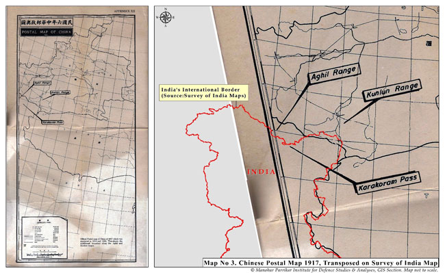
According to the ‘pamphlet’ titled “Sino-Pakistan ‘Agreement’ March 2, 1963; Some Facts”, released by the Government of India on March 16, 1963, traditionally, the boundary to the west of the Karakoram Pass ran along the watershed, dividing the tributaries of the Yarkand and Hunza rivers, and connecting the various passes from the west to the east, i.e., Kilik, Mintaka, Karchanai, Parpik and Khunjerab. From Khunjerab, it crossed the Shaksgam River and ran along the Aghil mountains, across the Aghil, Marpo, the Shaksgam and Karakoram passes till the Kun Lun Range. The 1917 postal map of China29 (re-printed by the Chinese Government in 1919 and 1933; see Map 2) showed the southern boundary of Xinjiang at the Aghil and Kun Lun ranges. A 1762 map of Xinjiang also showed its southern frontier extending only up to the Kun Lun Range. However, these facts were overlooked in the egregious bargain struck by Pakistan to give away the Shaksgam Valley east of Hunza to China on a platter.
Pakistan’s Illegal Concessions to China – A Subterfuge
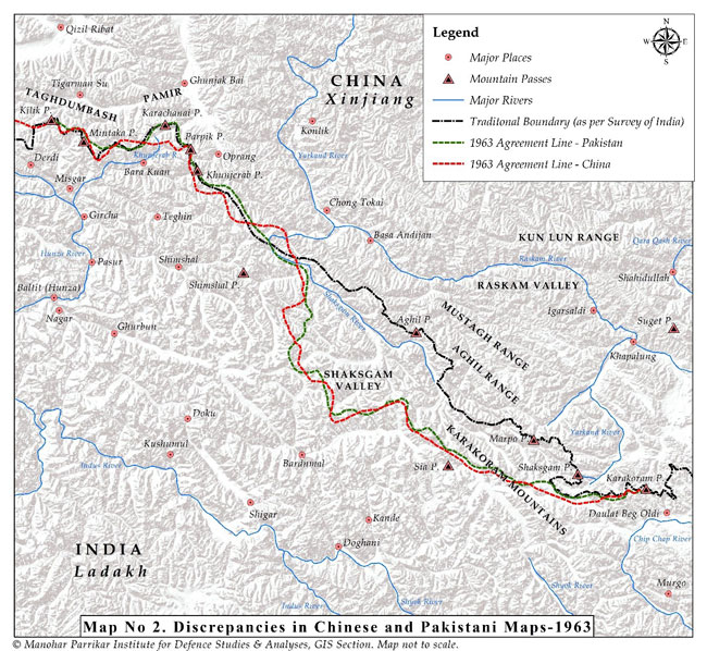
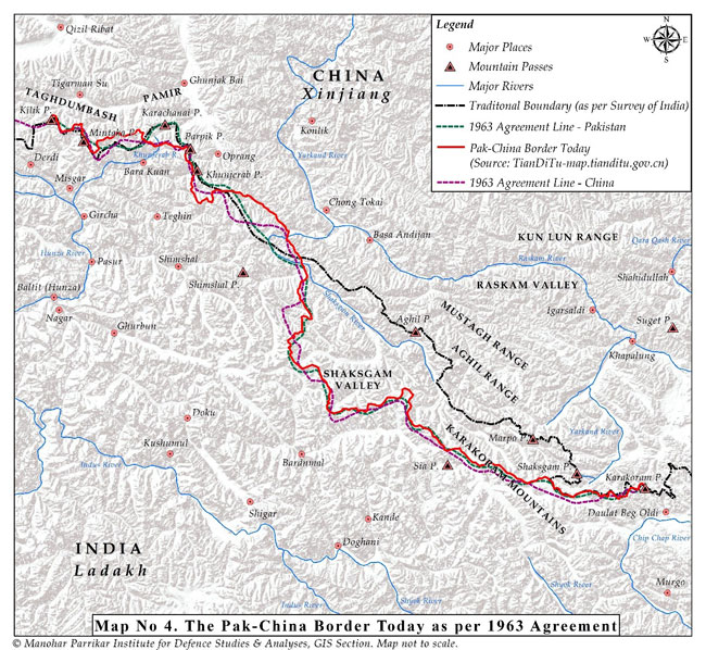
Pakistani concessions to China were largely kept away from the public eye in Pakistan. The negative press, such as there was in Pakistan, was conveniently brushed aside. It was also forgotten that the phrase used in the joint communique of May 1962, i.e., “the area, the defence of which is the responsibility of Pakistan”, was suitably altered in the agreement of March 02, 1963 as an area covering “contiguous areas, the defence of which is under the actual control of Pakistan”, in order to cloak Pakistan’s disproportionate concessions to China. The fact that there were discrepancies [Map 3] even in the maps circulated by the two countries depicting this border following the agreement was pointed out in the Indian ‘pamphlet’ cited above. Of course, these discrepancies have been resolved now [Map 4], but the falsity of the Pakistani assertion can be clearly noticed in these maps.
Ignoring all this, Bhutto thundered in the UNSC on March 26, 1963 and also later in the Pakistan National Assembly on July 17, 1963 that Pakistan had gained some 750 square miles (1,942 sq kms) of land, including the Oprang Valley and the Darband-Darwaza pocket along with its salt mines, as well as access to all passes along the Karakoram Range and control of two-thirds (later three-fourths) of the K-2 mountain including the summit. In reality, historically speaking, China had no claims to the K-2 mountain. In explaining the deal, Bhutto went on to state:
It is a matter of the greatest importance that through this agreement we have removed any possibility of friction on our only common border with the People’s Republic of China. We have eliminated what might well have become a source of misunderstanding and of future troubles…An attack by India on Pakistan would no longer confine the stakes to the independence and territorial integrity of Pakistan. An attack by India on Pakistan would also involve the security and territorial integrity of the largest state in Asia.30
Most leaders in Pakistan, including Ghulam Abbas, the leader of All Jammu and Kashmir Muslim Conference, hailed the agreement. Abbas even called China, “a dependable friend and ally” and “whose friendship could be of great value in liberating Kashmir from India”.31 The entire negotiation process was witness to the tame surrender by the Pakistan leadershipto Chinese bullying and, perhaps, also a Faustian bargain for buying Chinese goodwill as a reliable and steadfast ally against India.
The China-Pakistan collusion was clearly evident in the process and China became a direct party to the Kashmir issue both by concluding the 1963 agreement with Pakistan and taking the trans-Karakoram tract and, earlier, by occupying Aksai Chin. Article VI of the 1963 border agreement unambiguously mentions that:
….after the settlement of the Kashmir dispute between Pakistan and India, the sovereign authority concerned will reopen negotiations with the Government of the People's Republic of China on the boundary as described in Article Two of the present agreement [defining the border alignment], so as to sign a formal boundary treaty to replace the present agreement, provided that in the event of the sovereign authority being Pakistan, the provisions of the present agreement and of the aforesaid protocol shall be maintained in the formal boundary treaty to be signed between the People’s Republic of China and the Islamic Republic of Pakistan.
India’s contention was, and is, that Pakistan did not have the sovereign authority to enter into a territorial agreement with China given India’s legal claim to the State of Jammu & Kashmir.
Under international law, the right of entering into treaties and agreements is an attribute of sovereignty. Furthermore, a sovereign cannot presume to exercise sovereign functions in respect of territory other than its own. Having regard to the UN resolutions of January 17, 1948; August 13, 1948; and January 5, 1949 (UNCIP Resolutions), it is clear that Pakistan cannot (and does not) claim to exercise sovereignty in respect of Jammu & Kashmir.32
Interestingly, quoting Article VI of the 1963 agreement, Bhutto had said in the UNSC:
….Article 6 of the Sino-Pakistan Boundary Agreement makes it clear that the Agreement is of a provisional nature between Pakistan and China, and that after the settlement of the Kashmir dispute, the sovereign authority that will emerge in Jammu and Kashmir, will reopen negotiations with the Government of the People’s Republic of China, so as to sign a formal boundary treaty to replace the present Agreement.33
He also stated that this was in conformity with the stand of the Government of Pakistan in the letter of 3 December 1959, to the UNSC in the context of the Sino-Indian dispute over the boundary of Ladakh, which said:
….my Government is bound by its duty to declare before the Security Council that, pending determination of the future of Kashmir through the will of the people impartially ascertained, no position taken or adjustments made by either of the parties to the present controversy between India and China or any similar controversy in the future shall be valid or affect the status of the territory of Jammu and Kashmir.34
China’s actions in occupying Aksai Chin, and subsequently, in usurping the Shaksgam tract in 1963, did have a direct bearing on the territory of Jammu & Kashmir. Given that China had become a party to the territorial dispute in Jammu & Kashmir, it was naturally inclined towards settlement of the issue in favour of Pakistan, in order to preserve its territorial gains from the 1963 agreement.
On the basis of this agreement, China has carefully nurtured Pakistan as a quasi-colony over the years. As Chinese power grew and that of Pakistan withered because of its self-defeating foreign and security policies, China found it easy to manipulate Pakistani leaders at will to strengthen its control over Pakistan. The Karakoram Highway and the China-Pakistan Economic Corridor (CPEC) both use this contested frontier to bring the two countries together in a closer embrace and help China build an alternative lifeline to the Arabian Sea. India has consistently registered its protest at the route of the so-called economic corridor which traverses through terrain that legitimately belongs to India.
Conclusion
Unfortunately, China’s entanglement in the Kashmir issue has not received adequate attention of the strategic analysts and commentators, both in India and externally. China has had a free run so far and feels comfortable raising the issue precisely because its own status as an occupier of territory in Jammu & Kashmir has not been adequately publicised.
That China is an interested party to the dispute and has played an opportunistic historical role in adding to the complexity of the issue is a fact which should be brought to light in scholarly writings as well as in statements at the UN or any other international fora whenever the occasion presents itself in response to Pakistan raking up the issue of Jammu & Kashmir, singly or in tandem with China. This would be consistent with India’s position on Jammu & Kashmir in terms of its cartographic depictions as well as statements and resolutions in the Parliament over the years.
The maps produced here have been adapted from the maps provided in “Sino-Pakistan ‘Agreement’ March 2, 1963, Some Facts”, External Publicity Division, Ministry of External Affairs, Government of India, March 16, 1963.
Different Claim Lines Along Kashmir-Xinjiang Border-1962

Discrepancies in Chinese and Pakistani Maps-1963
Chinese Postal Map 1917, Transposed on Survey of India Map
The Pak-China Border Today as per 1963 Agreement
Views expressed are of the author and do not necessarily reflect the views of the Manohar Parrikar IDSA or of the Government of India.
- 1. Official Twitter Account of the Office of Shri Amit Shah, Union Home Minister, Twitter Post, August 06, 2019, 3:05 PM. Also see “When I talk about J&K, PoK, Aksai Chin are included in it: Amit Shah in Lok Sabha”, The Indian Express, August 06, 2019.
- 2. “Foreign Ministry Spokesperson Hua Chunying's Remarks on the Current Situation in Jammu Kashmir”, Ministry of Foreign Affairs of the People’s Republic of China, August 06, 2019.
- 3. “India’s Right of Reply”, 75th Session of the United Nations General Assembly, Permanent Mission of India to the UN, September 25, 2020.
- 4. “Foreign Ministry Spokesperson Zhao Lijian's Regular Press Conference on October 13, 2020”, Ministry of Foreign Affairs of the People’s Republic of China, October 13, 2020.
- 5. “Transcript of Virtual Weekly Media Briefing by the Official Spokesperson (15 October 2020)”, Ministry of External Affairs, Government of India, October 16, 2020.
- 6. The discussion in this section is based on a detailed historical account provided by Gondker Narayana Rao, who served as an Advisor to the Indian delegation which discussed the border question with the Chinese officials in Beijing, New Delhi, and Yangon in 1960, in his book The India-China Border: A Reappraisal, Asia Publishing House, Delhi, 1968, pp. 41-60.
- 7. G. J. Alder, British India's Northern Frontier, 1865-95: A Study in Imperial Policy, Royal Commonwealth Society, Longmans, London, 1963, p. 1.
- 8. See Gondker Narayana Rao, n. 6, p. 42.
- 9. William Moorcroft (1767-1825), an Englishman, a veterinarian and explorer, employed by the East India Company, travelled extensively throughout the Himalayas, Tibet and Central Asia. He stayed in Leh in 1820-22. His book is an important source of information for historians and geographers. See William Moorcroft and George Trebeck, Travels in the Himalayan Provinces of Hindustan and the Panjab; in Ladakh and Kashmir; in Peshawar, Kabul, Kunduz, and Bokhara, 1819-1825, Prepared for the Press, from Original Journals and Correspondence, by Horace Hayman Wilson, Vol. I, Published under the Authority of the Asiatic Society of Calcutta, John Murray, London, 1841.
- 10. Ney Elias (1844-1897) was an explorer, geographer, and a diplomat, most known for his extensive travels in the Karakoram, Hindu Kush, Pamirs, and Turkestan regions of High Asia and for providing strategic information to the British on frontier politics. His accounts are available in the Indian National Archives.
- 11. Francis E. Younghusband (1863-1942) was a British Army officer and explorer. He is known for his travels in Kashmir, the Far East and Central Asia. He led the 1904 British expedition to Tibet. He held official positions including British Commissioner to Tibet and President of the Royal Geographical Society. See his book Report of a Mission to the Northern Frontier of Kashmir in 1889, Printed by the Superintendent of Government Printing, Calcutta, India, 1890 [Available at Foreign Office Library, London].
- 12. See Gondker Narayana Rao, n. 6, p. 44.
- 13. Ibid., pp. 48-49.
- 14. Ibid., p. 46.
- 15. For a detailed account, see Parshotam Mehra, An 'Agreed' Frontier: Ladakh and India's Northernmost Borders, 1846-1947, Oxford University Press, Delhi, 1992, pp. 70-71.
- 16. That the Russians were quietly instigating China, "by threat or otherwise", to retain its hold over Hunza, was not unknown to the British. A mention of Macartney's note to India, dated December 19, 1891, is made in Parshotam Mehra's book. Ibid. p. 73.
- 17. Quoted in Gondker Narayana Rao, n. 6, p. 49.
- 18. George Macartney (1867-1945) was half-Chinese and served the British Indian Government as Consul General to Kashgar (1908-1918). He was first sent as ‘Special Assistant for Chinese Affairs to the British Resident in Kashmir’ in 1890. In fact, he helped Younghusband as an interpreter. The Chinese were suspicious of his posting and accepted him as a Consul only in 1908. He played a role in developing a ‘Line’ which was proposed by the British to China as the boundary in the Aksai Chin area in 1899, via its envoy to China, Sir Claude MacDonald. The line came to be known as the Macartney-MacDonald Line.
- 19. Major General John Charles Ardagh (1840-1907) was an Anglo-Irish officer of the British Army. He served in different capacities as a military engineer, surveyor, intelligence officer, and a colonial administrator. Along with William Johnson (d. 1883), British surveyor in the Great Trigonometric Survey of India and later Governor of Ladakh, he developed a line that was proposed as a boundary between Xinjiang and Tibet along the crest of the Kun Lun Mountains north of the Yarkand River. This was not acceptable to the Chinese.
- 20. See Parshotam Mehra, n. 15, p. 74.
- 21. In 1899, Claude Maxwell MacDonald (1852-1915), a British soldier and diplomat and Her Majesty's Minister in China (1896-98), authored a diplomatic note with George Macartney, the British Consul General in Xinjiang (1908-1918), which proposed a new delineation of the border between China and British India in the Karakoram and Aksai Chin areas, known as the Macartney–MacDonald Line, which was not formally accepted by China.
- 22. Adelbert Cecil Talbot (1845-1920) served in the British army and civil service during 1867-1900. He joined the Indian Political Service in 1873 and served as Resident in Kashmir during 1896-1900.
- 23. Vincent Arthur Henry McMahon was a British Indian Army officer and a diplomat. He also served as an administrator in British India and worked as a Political Agent in Gilgit and later as Commissioner of Balochistan (1909-1911). When McMahon was the Political Agent of Gilgit, he wrote a report titled "Hunza's Relations with China", wherein he stated that "Hunza's vassalage to both China and Kashmir was purely nominal".
- 24. A. G. Noorani, India-China Boundary Problem, 1846-1947: History and Diplomacy, Oxford University Press, New Delhi, 2011.
- 25. Chinese Premier Zhou En-Lai wrote: “I wish to point out that the Sino-Indian boundary has never been formally delimitated. …there are certain differences between the two sides over the border question…The latest case concern[s] an area in the southern part of China’s Sinkiang Uighur Autonomous Region, which has always been under Chinese jurisdiction…And the Sinkiang –Tibet highway built by our country in 1956 runs through that area. Yet recently the Indian Government claimed that that area was Indian territory. All this shows that border disputes do exist between China and India.” For full-length citation, see “Letter from the Prime Minister of China to the Prime Minister of India, 23 January 1959”, in Notes, Memoranda and letters Exchanged and Agreements signed between The Governments of India and China 1954 –1959, White Paper I, Ministry of External Affairs, Government of India.
- 26. Indian Ambassador R. K. Nehru had a meeting with Chinese Prime Minister Zhou En-Lai and the Vice Foreign Minister Chang Han-fu on March 15, 1956, following which he wrote this note, wherein he mentioned that Premier Zhou felt that “the US had no reason to intervene in the Kashmir question. Moreover, Kashmir people had already expressed their will”. He went on to tell the Ambassador that he would tell the Pakistani Premier when he would visit Peking that “it was most unwise to include Kashmir question in the [US-Pak] Karachi Communique and that it was a method destined to be defeated”. See “Karachi Communique and Indo-Pak Relations”, in Avtar Singh Bhasin (ed.), India-China Relations 1947-2000: A Documentary Study, Vol. II, Ministry of External Affairs, Government of India, Geetika Publishers, New Delhi, 2018, p.1594.
- 27. In his talks with the Secretary General of the Indian Ministry of External Affairs on March 16, 1956, Premier Zhou asked: “Can you cite any document to show that we have ever said that Kashmir is not a part of India?” He also said that Pakistan had proposed border talks but the Chinese Government had “not discussed with them anything so far”. See “Sino-Pakistan ‘Agreement’ March 2, 1963, Some Facts”, External Publicity Division, Ministry of External Affairs, Government of India, March 16, 1963, p. 15.
- 28. In the “Note”, the Chinese Ministry of Foreign Affairs makes the following assertion: “The Indian note alleges that the Chinese Government accepted without reservation the position that Kashmir was under Indian sovereignty, that there is no common boundary between China and Pakistan, and that therefore, China has no right to conduct boundary negotiations with Pakistan. This allegation is untenable. When did the Chinese government accept without any reservation the position that Kashmir is under Indian sovereignty?...This is not only a unilateral misrepresentation of facts but a delusion imposed on others.” See “Note given by the Ministry of Foreign Affairs, Peking, to the Embassy of India in China, 31 May 1962”, in Avtar Singh Bhasin (ed.), India China Relations 1947-2000: A Documentary Study,Vol. IV, Ministry of External Affairs, Government of India, Geetika Publishers, New Delhi, 2018, p.3691.
- 29. See Appendix XII in “Sino-Pakistan ‘Agreement’ March 2, 1963, Some Facts”, External Publicity Division, Ministry of External Affairs, Government of India, March 16, 1963.
- 30. Z. A. Bhutto, Foreign Policy of Pakistan: A Compendium of Speeches Made in the National Assembly of Pakistan, 1962-64, Pakistan Institute of International Affairs, Karachi, 1964. Also see “Address to National Assembly on Reappraisal of Foreign Policy — Western Arms for India — Negotiations with India on Kashmir—Boundary Agreement with China July 17th 1963”, Zulfikar Ali Bhutto Speeches from 1948–1965.
- 31. Cited in Manzoor Khan Afridi and Abdul Zahoor Khan, “Pak-China Boundary Agreement: Factors and Indian Reactions”, International Journal of Social Science Studies, 4 (2), February 2016, p. 3.
- 32. Cited by Claude Arpi, “The Truth About Ladakh’s Shaksgam: Correcting Historical Wrongs in J&K”, Deccan Chronicle, November 18, 2019.
- 33. For Zulfikar Ali Bhutto’s speech at the UNSC on March 26, 1963, see “The Sino-Pakistan Boundary Agreement March 26, 1963”, Zulfikar Ali Bhutto Speeches from 1948–1965.
- 34. Ibid.